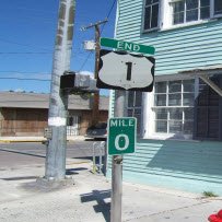
Mile Markers Point The Way
On Overseas Highway

How do you know where you're going as you drive towards the Florida Keys?
Mile Markers are the answer.
The Overseas Highway is the only way you’re gonna get to our islands by car.
And one thing you need to know is it winds in quite an arc, so unlike some major cities it is almost impossible to issue directions as “Go North until…………” which is why these sign posts that you see on the route are really useful.
You see all the addresses along this road are provided with the prefixes MM, so the ones up in Florida City will start with MM126, whilst in Key West they will end up with MM 0.
You will see the small green markers with white number on them all the way as you drive to US1, as they are positioned at mile intervals
The mile markers that run down Overseas Highway or US1 as it is also known descend in order to know that you are heading towards the southern most island Key West.
If they are going up you're going the wrong way.
So what else can we tell you?
Well, to make it even easier any place on the right side of the road next to the Florida Bay or Gulf of Mexico is known as Bayside.
The opposite side of the road, with views of the Atlantic Ocean is called Oceanside.
Seems sensible?
We think so.
Where The Markers Appear On Route
For an excellent breakdown of when and where they appear go to
www.keyshistory.org/MileMarkerChart.html
Like This Page?
New! Comments
Have Your Say About What You've Just Read!